Call us (84) 43 974 6373
Email info@jeweltours.com
Phu Quoc National Park
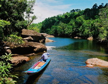 With an area of 56,200 ha, Phu Quoc is the largest in an archipelago of 14 islands. Phu Quoc island lies in the Gulf of Thailand, about 40 km due west of the Vietnamese mainland. Phu Quoc National Park is situated in the north-east of the island, and the northern and eastern boundaries of the national park follow the coastline. The topography of the national park is hilly, although not particularly steep. The highest point in the national park is Mount Chua at 603 m. The national park is drained by numerous, mainly seasonal, streams. The only sizeable river on the island is the Rach Cua Can river, which drains the southern part of the national park, and flows into the sea on the west coast of the island.
Phu Quoc National Park contains many forest types and landscapes including mangroves and wet lands, sparse forested areas, coastal vegetation and forest on rocky mountains. Studies by the Vietnam-Russia Tropical Center in 2005 recorded 1,164 higher plant species, including 23 orchid species and 12 rare plant species including the globally endangered Paphiopedilum callosum which was recently found in the park. A total of 208 animal species were recorded in the National Park, including 28 mammals, 119 birds, 47 reptiles and 14 amphibians. Of these animal species, 6 mammal, 4 bird and 9 reptile species are globally endangered. The rare species include lorises, the long-tailed macaque, silver langur, otter, and hornbill.
Tourism activities
Riding motorbike
Hire motorbike on your own and explore the northerly parts of the island. The best areas and most forested parts can be found on the road toward Ganh Dau. To get there, take the road from Duong Dong towards Bai Thom and turn off toward Ganh Dau, the National park becomes more apparent the closer you get to Ganh Dau Village.
Trekking
Walking Trails are limited, though for a great way to experience the national park there is a good walking trail 5kms before Ganh Dau, where the going is relatively easy and trail wide enough to take in the surrounding environment. The walk is a particularly pleasant way to escape the heat, as the vegetation provides cover from the heat of the sun. Take the same road mentioned previously towards Ganh Dau and 100m after the 5km Ganh Dau road marker on the left hand side you’ll find an opening in the national park with a clearly defined walking trail which continues for a couple of kilometers. Note, besides the 5km Ganh Dau marker, the actual trail is not sign posted.
RELATED POST
-
.jpg)
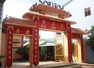
Hang Pagoda (Co Thach Pagoda)
Hang Pagoda, also called Co Thach Pagoda located at Binh Thanh Commune, Tuy Phong District, Binh Thuan Province, 105km north of Phan Thiet City. It was built in a large cave by Buddhist monk Bao Tang in the middle of the 19th century and rebuilt more majestically by Ho Cong Diem and named it Co...
-
Clay Pagoda
Soc Trang Clay Pagoda is situated at the heart of the city, with the more formal name Buu Son Tu. From the outside, the pagoda resembles more of a resident house than a pagoda, without any pillar or wooden panel like typical pagoda architecture.Like the Stork Garden of Tan Long, Clay Pagoda...
-
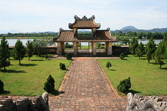
Hue Temple of Literature
The Temple of Literature is a worship temple founded by the Nguyen Dynasty to dedicate to celebrated scholars of Confucianism.In 1808, Gia Long and his Imperial Court decided to choose a low hill beyond the Thien Mu Pagoda, on the left bank of the Perfume River, i.e. the current position, to...
Your Prefer Place

Travel Styles in Vietnam
Our Destinations
Show all destinations in VietnamNewsletter register
Be the first to know about our exclusive travel offers and tour updates.
Member & Association


Add: 18th Floor, VTC Online building, 18 Tam Trinh, Hai Ba trung, Ha Noi, Vietnam
Tel: (84) 43 974 6373 *Fax: (04) 3974 6374
Working hours : 8:15 - 17:45 from Monday to Friday and Morning Saturday
Email: info@jeweltours.com
Website: https://www.holidayexplore.com/
International travel license: 01-043/2009/TCDL-GP-LHQ.